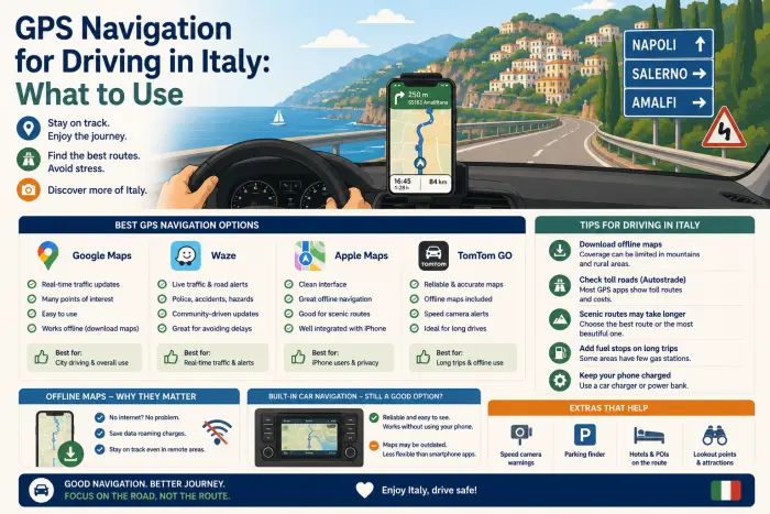
The rental counter will almost always offer a GPS unit as an add-on, priced by the day, and for most travelers it’s one of the easier add-ons to decline. The overwhelming consensus among experienced Italy drivers isn’t close: a smartphone with offline maps downloaded in advance handles Italian roads, including remote countryside routes, just as well as — often better than — a rented GPS unit, at a fraction of the cost.
| Navigation Option | Typical Cost | Offline Capable | Speed Camera Alerts |
|---|---|---|---|
| Rental company GPS | ~€15/day | Yes | No |
| Google Maps (offline) | Free (data only when updating) | Yes | No |
| Waze | Free (data for full features) | Limited | Yes |
| eSIM data plan | Often under total GPS rental cost for a week | N/A (enables live data) | Depends on app used |
🗺️ Quick Take: Rental company GPS units typically cost around €15 per day, which adds up fast over a week-long trip — often more than the cost of a data plan or eSIM for the whole trip. Google Maps or Waze with offline maps downloaded before you land works reliably even in areas with spotty signal, and Waze specifically alerts for speed cameras, which matters given how aggressively Italy enforces speed limits through fixed and mobile camera systems.
Speed camera alerts matter more than they might seem — our Italy speed limit guide covers just how easy it is to get caught, and how the fines actually work.
Why Most Experienced Drivers Skip the Rental GPS
The math is fairly straightforward once you compare the actual costs: a rental company GPS unit at roughly €15 per day adds up to over €100 across a week-long trip, which is often more than the cost of an eSIM data plan covering your entire trip’s navigation needs — one of several avoidable add-ons covered in our guide to hidden costs when renting a car in Italy. Beyond cost, rented GPS units are frequently described as dated hardware compared to modern smartphone navigation, with less accurate routing and a less intuitive interface than apps most travelers already use daily at home.
This doesn’t mean a dedicated GPS device is never worth it — some travelers specifically prefer not relying on their phone’s battery or data for navigation and bring their own pre-owned GPS unit with updated European maps loaded — but renting one from the car company specifically is the option experienced Italy drivers consistently recommend skipping.
Setting Up Offline Navigation Before You Land
The practical setup most recommended: download offline map areas for your entire route in Google Maps (or a similar app) before your trip, while still connected to reliable WiFi at home. This allows turn-by-turn navigation to function without an active data connection for the core mapping and routing, which is particularly useful in rural areas of Umbria, Tuscany, or Lazio where cell signal can be inconsistent. Real-time traffic information does require an active data connection, so it’s a genuine trade-off, but core navigation continues working regardless.
A practical habit worth adopting: enter your destination and let the route calculate while you have WiFi or data, then switch to airplane mode or disable data before setting off — most navigation apps continue turn-by-turn guidance from the already-loaded route without needing continuous connectivity.
Why Waze Specifically Has an Edge in Italy
This is a genuinely practical differentiator worth calling out directly: Waze includes crowd-sourced alerts for speed camera locations, both fixed installations and mobile enforcement units, which is meaningfully useful in Italy given how frequently speed cameras appear on both urban roads and rural highways. Speed camera fines can be substantial and are often only discovered by the driver weeks after the trip, when the notice arrives by mail — an alert in the moment is a genuinely practical way to avoid an entirely preventable fine, especially given how easy posted limits can be to misjudge on unfamiliar roads.
Waze’s Other Italy-Specific Feature: ZTL Routing
Beyond speed camera alerts, Waze has a second Italy-specific feature worth setting up before you start driving: dedicated ZTL routing. Once you add your ZTL pass or permit information into the app’s settings, Waze factors restricted zones directly into its route calculations — either routing you around an active ZTL rather than through it, or clearly warning you if your planned route would take you into one. Even without adding any pass information, the app will still alert you if a route crosses into a restricted zone, which is a meaningfully more direct warning than a standard map simply not flagging the restriction at all.
This doesn’t replace actually understanding the rules — our ZTL guide covers how the zones and camera enforcement actually work — but it adds a real-time safety net on top of that knowledge, catching the kind of last-second wrong turn that’s easy to make in an unfamiliar city center. It’s a five-minute setup step worth doing before you leave your hotel on day one, not something to figure out mid-drive.
💸 Italy Car Rental Sale – Up to 40% Off Today
Find the cheapest car rental deals in Rome and across Italy. Compare prices instantly and lock in your discount before it's gone.
Data Plans, eSIMs, and Avoiding Roaming Charges
For travelers who want live traffic data and general connectivity beyond offline maps, an eSIM data plan purchased before the trip is generally the most cost-effective option, often available with a meaningful data allowance for a total cost well under what a week of a traditional carrier’s daily international roaming fee would run. Most current smartphones support eSIM technology, letting you keep your home number active for calls and texts on the physical SIM while using a separate eSIM specifically for data. This approach avoids the classic worry about accidentally burning through an expensive roaming data allowance while navigating.
What You Can’t Fully Rely On: Built-In Car Systems
Some rental vehicles include built-in GPS displays or smartphone integration (Apple CarPlay, Android Auto), but this is genuinely inconsistent and tied to the specific vehicle class and model you’re assigned — not something you can count on regardless of what you request. Economy and compact vehicle classes are less likely to include this than mid-size or higher categories, and even within the same category, the exact model (and therefore its tech features) varies by what’s actually on the lot the day you pick up. If built-in navigation or phone integration genuinely matters to your trip, it’s worth asking directly at the counter rather than assuming based on the vehicle class description alone — and having your phone’s own navigation ready as the reliable fallback regardless of the answer.
A Backup Worth Keeping: Road Signs by City Name
One adjustment worth making mentally before you start driving: Italian road signage points toward city names, not compass directions or route numbers the way many US drivers are used to. Knowing the name of the next major city or town along your route — not just “north” or “south” — makes reading highway signage considerably easier, and serves as a useful backup if your navigation app ever gives an ambiguous instruction at a complex intersection or roundabout. This pairs naturally with understanding Italy’s roundabout rules, since navigation apps sometimes struggle to clearly indicate which exit to take on a multi-lane roundabout, and knowing your next destination city by name helps you self-correct. Good navigation also matters for avoiding accidental entry into ZTL restricted zones, and for finding your way to a gas station when you need one in an unfamiliar area.
FAQ
Is it worth renting a GPS unit from a car rental company in Italy? Generally not, according to most experienced travelers — it typically costs around €15 per day, more than an eSIM data plan for the entire trip, while offering less accurate and less intuitive navigation than a modern smartphone app.
Does Google Maps work well for driving in rural parts of Italy? Yes, according to widespread traveler experience, provided offline maps are downloaded in advance — it reliably handles both urban and rural routes even with inconsistent cell signal.
Why do some drivers prefer Waze over Google Maps in Italy specifically? Waze includes crowd-sourced alerts for speed camera locations, which is particularly useful in Italy given how frequently these cameras are used for enforcement.
Can I navigate in Italy without buying a data plan or eSIM? Yes, to a significant extent — downloading offline maps before your trip allows turn-by-turn navigation without an active data connection, though real-time traffic updates do require data.
Are rental cars in Italy guaranteed to have built-in GPS or CarPlay/Android Auto? No, this varies by the specific vehicle class and model assigned at pickup and isn’t guaranteed regardless of what you request — it’s worth having a phone-based navigation backup regardless.
What’s the cheapest way to get data for navigation while driving in Italy? An eSIM data plan purchased before the trip is generally the most cost-effective option compared to a traditional carrier’s daily international roaming fee.
Do Italian road signs use compass directions like north and south? No, they generally point toward the name of the next major city or town along the route, which is worth knowing before you start driving to make sense of highway signage.
Should I bring my own dedicated GPS device instead of using my phone? It’s a reasonable choice for travelers who prefer not to rely on their phone’s battery or data, but for most travelers, a smartphone with offline maps is the more practical and cost-effective option.
Can Waze help me avoid ZTL fines in Italy? Yes — Waze has a dedicated ZTL routing feature that factors restricted zones into its directions and warns you if a planned route enters one, especially useful once you’ve added your permit details in the app’s settings.